Wednesday, August 31, 2005


Some photos taken August 29th by members of Webshots


Katrina slams Gulf Coast
The 53rd Weather Reconnaissance Squadron, known as the Hurricane Hunters of the Air Force Reserve, flew propeller-driven Lockheed-Martin WC-130 aircraft directly into the eye of Katrina. This archived photo shows the "stadium effect" that occurs in the eye of a strong hurricane--it's said to look like being in the middle of a stadium of clouds. The Hurricane Hunters' Web site includes videos that let you see what the eye of a hurricane looks like.
Credit: The Hurricane Hunters

Katrina swamps South
'Some of them, it was their last night on Earth'
By Joseph B. Treaster and Kate Zernike / New York Times

NEW ORLEANS -- Hurricane Katrina pounded the Gulf Coast with devastating force at daybreak Monday, sparing New Orleans the catastrophic hit that had been feared but inundating parts of the city and heaping damage on neighboring Mississippi where it tossed boats, ripped away scores of roof tops and left many of the major coastal roadways impassable.
Packing 145-mph winds as it made landfall, Katrina left more than a million people in three states without power and submerged highways even hundreds of miles from the center of the storm.
Early today, Gov. Haley Barbour said the death toll in Harrison County, Miss., alone could hit as high as 80. Officials earlier reported 55 deaths, of which 50 were in Harrison County. Emergency workers feared they would find more dead among people believed to be stranded under water and collapsed buildings.
"Some of them, it was their last night on Earth," Terry Ebbert, chief of homeland security for New Orleans, said of people who ignored orders to evacuate the city of 480,000 over the weekend.

To read more of this article


Katrina slams Gulf Coast
The storm has passed, but the destruction done by Hurricane Katrina has become the new reality for Gulf Coast residents. The U.S. Coast Guard is among the agencies and services assessing the damage and conducting search-and-rescue operations.


Credit: Kyle Niemi/U.S. Coast Guard

Monday, August 29, 2005

New Orleans Braces for 'The Big One'

CNN report
Sunday, August 28, 2005; Posted: 8:41 p.m. EDT (00:41 GMT)

NEW ORLEANS, Louisiana (CNN) -- A solemn New Orleans Mayor Ray Nagin ordered mandatory evacuations Sunday as his city faced its worst fear -- the threat of a direct hit from a major hurricane that could swamp the low-lying city.
By mid-morning Sunday, Katrina was a Category 5 hurricane with maximum sustained winds near 175 mph. It was expected to make landfall Monday morning. Category 5 is the most intense category on the Saffir-Simpson scale of intensity.
Officials are particularly concerned about New Orleans because about 70 percent of the city is below sea level.
The city essentially sits in a bowl, protected by a series of levies that keep the Mississippi River waters out.
Nagin warned that Katrina's expected storm surge -- which could top 28 feet -- would likely topple those levies.
"We are facing a storm that most of us have feared," Nagin said. "I don't want to create panic, but I do want the citizens to understand that this is very serious, and it is of the highest nature."
Nagin said the city's shelters should be used as a last resort and said that people who use them should bring enough food, water and supplies to last for several days. He said that the Superdome, the city's main shelter, "is not going to be a very comfortable place at some point in time."
"The shelters will end up probably without electricity or with minimum electricity from generators in the end," Louisiana Gov. Kathleen Blanco said. "There may be intense flooding that will be not in our control which would be ultimately the most dangerous situation that many of our people could face."
Residents who had delayed their departure -- some not quite believing that Katrina could be the storm New Orleans authorities have always called "the Big One" -- jammed Interstate 10 westbound, prompting Blanco to urge evacuees to go north.
In worst-case scenarios, most of New Orleans would end up under 15 feet of water, without electricity, clean water and sewage for as long as six months. Even pumping the water out could take as long as four months to get started because the massive pumps that would do the job would be underwater.
Nagin also cautioned that the port of New Orleans handles much of the nation's oil transportation, meaning that an interruption in operations could have "a significant impact on the cost of oil."
He said it would likely take weeks for the city to return to any semblance of normalcy if the worst comes to pass. Federal Emergency Management Agency teams and other emergency teams were already in place to move in as soon as the storm was over, FEMA Under Secretary Michael Brown said.
New Orleans, a city of nearly half a million with a metropolitan area population of 1.3 million, dodged a bullet in 1998 when a Category 2 Hurricane Georges had a last minute change of route and made landfall near Biloxi, Mississippi. But Georges was close enough to push the Mississippi River to within one foot of the top of the levees between the river and the city.
The last hurricane to score a direct hit on New Orleans was Hurricane Betsy, a Category 2 with 105 mph winds when it came ashore in 1965. Betsy killed more than 70 people, its storm surge overflowing the levees and reaching the eaves of many buildings.
The levees are higher now, but Katrina is a stronger storm -- as strong as 1969's Hurricane Camille, which grazed New Orleans when it came ashore in Mississippi and killed more than 250 people.
"After Betsy these levies were designed for a Category 3," said Sheriff Jeff Hingle of Placquemines Parish, just southeast of New Orleans. "You're now looking at a Category 5. You're looking at a storm that is as strong as Camille was, but bigger than Betsy was size-wise. These levies will not hold the water back. So we're urging people to leave. You're looking at these levies having 10 feet of water over the top of them easily."
Two category 4 storms, in 1909 and 1915, each killed hundreds in the area, and 1964's Hurricane Hilda killed 38.
But the deadliest storm to hit southeastern Louisiana was an unnamed storm in 1893 that killed an estimated 2,000 people.


At 12:40 a.m. CDT (0540 UTC) on August 28th Katrina was upgraded to Category 4. Later that morning, Katrina went through a period of rapid intensification, with its maximum sustained winds reaching as high as 175 mph (280 km/h) (well above the Category 5 threshold of 156 mph (250 km/h)) and a pressure of 906 mbar by 1:00 p.m. CDT.
Nonetheless, on August 29th the system made landfall as a strong Category 4 hurricane at 6:15 a.m. CDT near Buras-Triumph, Louisiana with maximum sustained winds of 145 mph (235 km/h).

Hurricane Katrina is the third strongest hurricane on record to make landfall on the United States. The 15 to 30 foot (5 to 9 m) storm surge came ashore on virtually the entire coastline from Louisiana, Mississippi and Alabama to Florida. The 30 foot (10 m) storm surge recorded at Biloxi, Mississippi is the highest ever observed in America.

Picture taken on August 28th 2005 by NASA when Hurricane Katrina was near the peak of its intensity

Saturday, August 27, 2005

Katrina spent only a few hours over South Florida. Katrina was predicted to go across South and Southwest Florida. However, Katrina moved farther to the south than expected and soon regained hurricane strength after emerging into the Gulf of Mexico on the morning of August 26.
Katrina then quickly strengthened to Category 2 and its pressure dropped to 971 mbar, which prompted a special update from the NHC at 11:30 a.m. EDT (1530 UTC). At 5:00 a.m. EDT (0900 UTC) on August 27, Katrina's pressure dropped to 945 mbar and it was upgraded to Category 3. The same day President Bush declared a state of emergency in Louisiana, two days before the hurricane made landfall [10].

Friday, August 26, 2005

CNN Friday, August 26, 2005; Posted: 12:28 a.m. EDT (04:28 GMT)


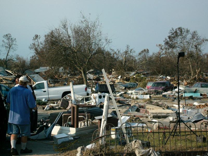
HOLLYWOOD, Florida (CNN) -- Hurricane Katrina lumbered ashore Thursday evening with punishing winds and torrential rain in densely populated southeast Florida, leaving at least two people dead and more than 1 million without electricity.
A man in Fort Lauderdale was killed when a large ficus tree fell onto his car on a street near downtown, bringing power lines down with it, police spokesman Bill Schultz said.
Another man in Plantation died when he was hit by a tree after going outside to inspect damage from a branch that fell on his mobile home, Plantation Police Sgt. Al Butler said.
A third man died in Cooper City when the car he was driving struck a tree as he was attempting to avoid a downed tree on a road, said Broward County Sheriff's Office spokesman Hugh Graf.
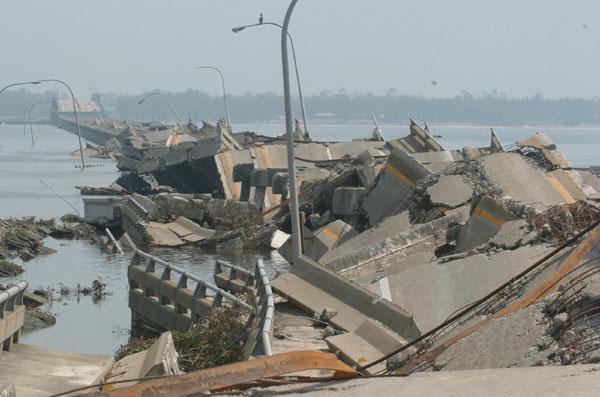
An overpass under construction over Florida Highway 836 west of Miami also collapsed during the storm. There were no immediate reports of injuries, according to Miami-Dade Metro Police.
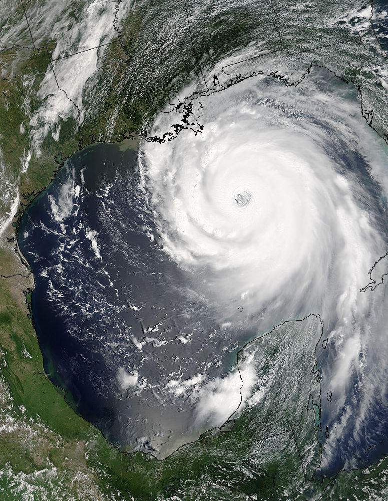
At 11 p.m. ET, despite being over land for more than four hours, Katrina's maximum sustained winds were still being clocked at 75 mph, just 5 mph weaker than when the storm came ashore between Hallandale Beach and North Miami Beach at 6:30 p.m.
Instead of going across the Florida peninsula as projected, Katrina took a slight jog to the southwest after making landfall, pushing the brunt of the storm into Miami-Dade County.
At 11 p.m., the center of the hurricane was 35 miles southwest of Miami and 20 miles northwest of Homestead.
Thursday night, Florida Power and Light reported that 525,000 customers in Miami-Dade County were without power, along with 477,000 in Broward County and 76,000 in Palm Beach County.
"We're well over a million, and it doesn't look like it's going to ease up," said utility spokesman Bill Swank. The company was bringing in more than 4,100 electrical workers from other areas to help restore power.
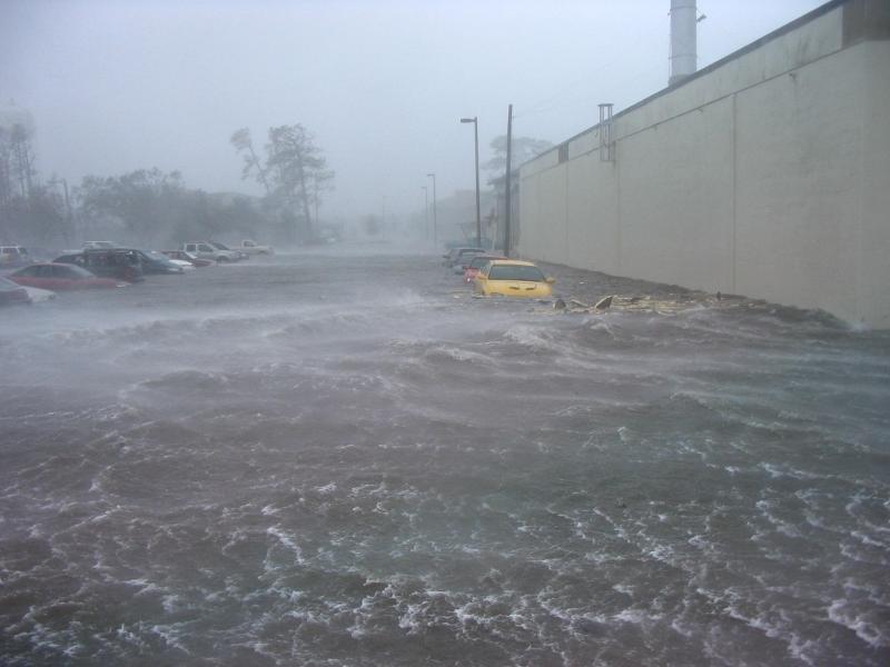
The storm was classified as a minimal, Category 1 hurricane, making serious wind damage unlikely. However, flooding was a major concern from the slow-moving storm. Radar showed Katrina, which was moving at a mere 6 mph, was dumping 1 to 2 inches of rain an hour.
Six to 10 inches of rain were likely along its path, with up to 15 inches possible in some isolated areas, forecasters said.
'Take this seriously'
Throughout Thursday, officials warned the more than 5 million people living in southeast Florida not be be lulled into a false sense of security by the storm's relatively modest winds.
At a news conference, Florida Gov. Jeb Bush, whose state was battered by four powerful hurricanes last year, made the point that any hurricane is dangerous, regardless of its category.
"Hurricanes are hurricanes, and they bring with them the possibility of really severe flooding and wind damage, so it's important to take this seriously," Bush said.
People were being told to take cover in their homes. Residents of low-lying areas, barrier islands and those living in mobile homes were urged to evacuate, though evacuations remained mostly voluntarily.
The only mandatory evacuation was for barrier islands and low-lying areas in southern Palm Beach County, around Boca Raton.
Interstate 95, the main north-south freeway along the east coast, was jammed with traffic Thursday afternoon, as people left work early to get home before the storm hit.
In Hollywood, Alberto Soddu was buying plywood to cover some of his windows that aren't protected by shutters.
"After the [Hurricane] Andrew experience, I am taking it seriously," he told CNN.
Hurricane Andrew, Category 5 storm, slammed into south Florida on August 24, 1992, causing $30 billion in damage. Forty deaths were attributed to the storm.
Travel disrupted
Fort Lauderdale-Hollywood International Airport shut down Thursday evening. While airports in West Palm Beach and Miami did not officially close, airlines serving both cities began canceling most of their flights. Ports in the area also closed.
A hurricane warning -- meaning winds of at least 74 mph were expected within 24 hours -- was in effect from Jupiter Inlet south to Florida City, including Lake Okeechobee to the west.
The storm was relatively small. The eye was only 10 miles across, and hurricane force winds extended only 15 miles from the center.
The long-term forecast track from the hurricane center showed Katrina weakening and crossing the Florida peninsula Friday, then moving out over the Gulf of Mexico and sweeping north toward the hurricane-weary northern Gulf Coast.
The storm could make a second landfall late Sunday or early Monday.
"We're becoming very concerned that as it moves in the gulf, even though it will weaken over the peninsula, it will have a very good chance to restrengthen into a hurricane over the Gulf of Mexico," said Max Mayfield, director of the hurricane center.
The stretch of Gulf Coast from Louisiana to the Florida Panhandle already has been hit with three tropical systems this year -- Hurricane Dennis and tropical storms Arlene and Cindy.
Because of the erratic nature of hurricane movement, long-range forecasts often change.
Thursday evening, a tropical storm warning was issued for the west coast of the Florida peninsula from Longboat Key near Bradenton south to Florida Bay; for the Florida Keys; and for the east coast from Florida City southward to Florida Bay and from Jupiter Inlet north to Vero Beach.
The warning means tropical storm conditions, including sustained winds of at least 39 mph, were expected in the next 24 hours.
Katrina is the 11th named storm of the busy 2005 Atlantic hurricane season, with more than three months to go.
By contrast, over the past 60 years the average number of named storms in an entire season was just 10, according to the National Oceanic & Atmospheric Administration.
The large number of early storms prompted forecasters to update their estimates of hurricane activity this year, projecting that as many as 21 named storms might develop.
Historically, the busiest months for tropical activity are September, August and October -- in that order.
CNN's Jason Carroll, Jacqui Jeras, Rob Marciano and Ed Zarrella contributed to this report.

The Beginning of Hurricane Katrina

The U.S. National Hurricane Center (NHC) issued a statement on August 23rd saying that Tropical Depression Twelve had formed over the southeastern Bahamas. The system was upgraded to Tropical Storm Katrina on the morning of August 24th.
Katrina became the fourth hurricane of the 2005 season on August 25th and made landfall later that day around 6:30 p.m. between Hallandale Beach and Aventura inFlorida.

Hurricane Katrina

Hurricane Katrina was a demonstration of how destructive natural forces can be. After Hurricane Katrina's short devastating visit an area of one of the world's richest and powerful nations was left little better off than as if it had happened in a third world country.
Technology warned of Hurricane Katrina's impending arrival, but could not predict the extent of damage and loss of lives that it caused. Homes that had survived through many tropical storms and at least two hurricanes could not withstand the power of Hurricane Katrina. Although many people had time to evacuate New Orleans, other areas were caught unprepared as Hurricane Katrina altered course. The twenty percent of the residents of New Orleans who did evacuate could not have even come close to anticipating the extent of the destruction and devastation that they experienced as a result of Hurricane Katrina visit.